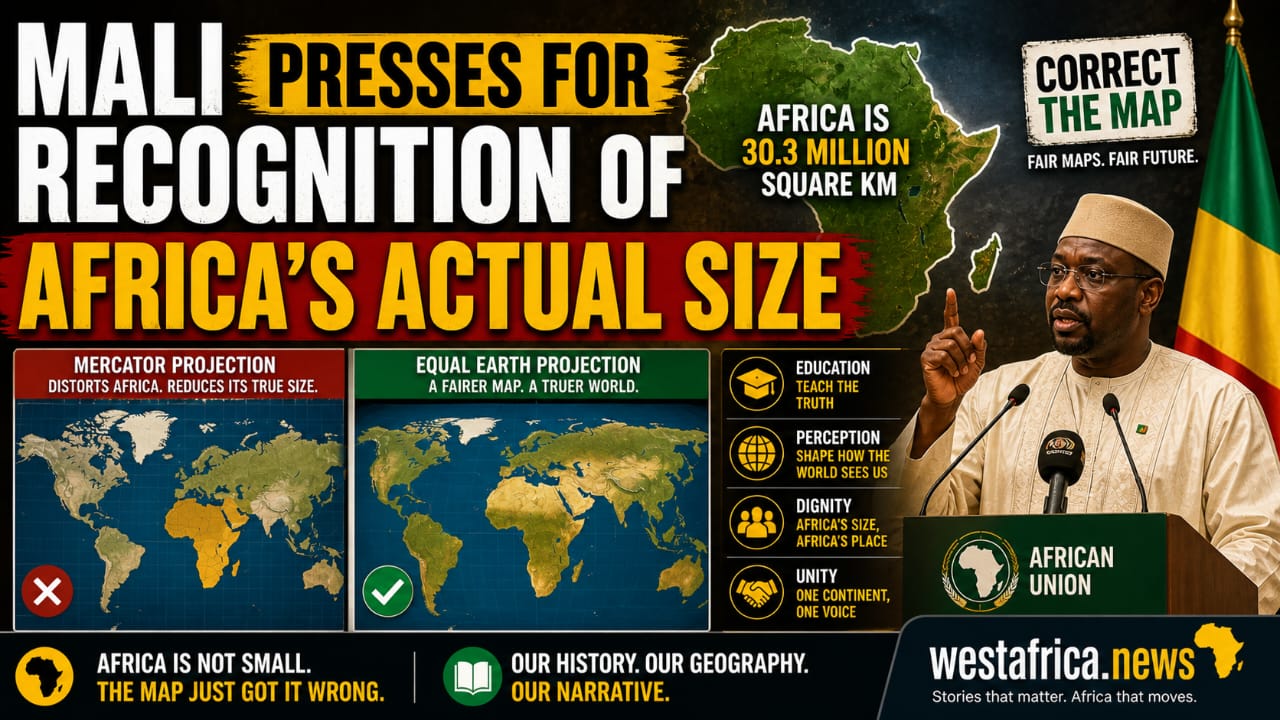
With African Union support for fairer world maps, the campaign to correct Africa’s distorted image becomes a question of geography, education and global perception.
For generations, Africa’s place on the world map has carried a quiet but powerful distortion. The familiar Mercator projection, created in the 16th century for navigation, has long enlarged regions closer to the poles while visually reducing the scale of landmasses nearer the equator. The result is that Africa, the world’s second-largest continent, has often appeared far smaller than it truly is.
Now, Mali and other African voices are pressing for that distortion to be corrected. Their call has found wider continental support, with the African Union backing efforts to replace the outdated Mercator projection with fairer alternatives such as the Equal Earth map, which better reflects the relative sizes of countries and continents.
The campaign, popularly framed as “Correct The Map,” argues that the matter goes beyond classroom geography. It is about perception, education, history and global imagination. On the Mercator map, Greenland and parts of Europe appear disproportionately large, while Africa is visually diminished. In reality, Africa is about 30.3 million square kilometres — large enough to contain the United States, China, India, Japan, Mexico and much of Europe with room still left over.
Supporters of the campaign say the map many children grow up seeing has helped shape a false mental picture of the world. Africa’s physical vastness, demographic weight, mineral wealth, cultural diversity and geopolitical importance are all made to seem smaller when the continent is literally reduced on the page.
The African Union’s support gives the campaign fresh diplomatic weight. It signals that African institutions are no longer treating cartographic distortion as a harmless technical matter, but as part of a larger struggle over how the continent is represented in global education, media, policy and public consciousness.
No flat map can perfectly reproduce the globe, but campaigners argue that some distortions are more damaging than others.
The Mercator projection was useful for sailors because it helped navigation along straight compass lines. But as a general world map, especially in schools and public institutions, it gives a misleading view of relative size. The Equal Earth projection, by contrast, seeks to show countries and continents in more accurate proportion, even if some shapes are adjusted in the process.
For Africa, the issue is more than measurement. It is about dignity, self-understanding and the continent’s rightful place in the world. The demand is simple: if the world is to teach geography, it should begin by showing the world more honestly.
As Mali and other African voices press the case, the debate has become part of a wider continental conversation — one that asks not only how Africa is mapped, but how Africa is seen.